 |
|
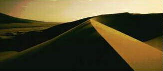
Great Sand Dunes National Monument was established in 1932. The monument, located in the San Luis Valley on the Western Slope of the Sangre de Cristo Mountains, contains some of the highest sand dunes in the United States. Some of the dunes exceed 700 feet in height and were deposited over thousands of years by winds blowing through passes in the mountains. The park covers about 38,662 acres and has water to cool your feet at the base between the parking area and the foot of the dunes. GPS Coordinates: 37°43'56.30"N 105°30'42.07"W Other Links to the Great Sand Dunes: |
 |
|
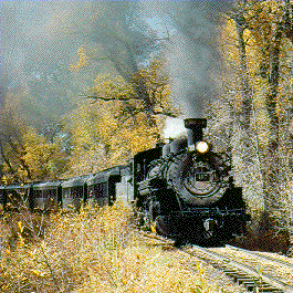
Antonito, Colorado in the San Luis Valley is the main station for the Cumbres & Toltec Scenic Railroad which dates back to 1871. It is the highest and longest narrow-gauge railroad in North America. You can catch the train there and take an exciting railroad trip to Chama, New Mexico through some of Colorado and New Mexico's most beautiful country. GPS Coordinates: 37° 4'7.04"N 106° 0'51.12"W |
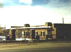 |
| Fort Garland, built in 1858, was named for Brevet Brigadier General
John Garland, then in command of the Department of New Mexico. This fort
was built to protect the settlers from the Indians. In 1865 Kit Carson was
given a commission as brigadier general and cited for gallantry and
distinguished service. In May of 1866, Kit Carson and his Hispanic 1st New
Mexico Volunteer Regiment were ordered to Fort Garland where they remained
until Ill health forced him to resign the following year 1867. GPS Coordinates: 37°25'25.86"N 105°25'53.66"W See More Photos & Video Here |
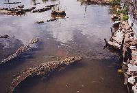 |
| Colorado Gators is located in
the San Luis Valley and provides great experience and entertainment for
young and old. Brave young visitors may even earn a Certificate of Bravery
for holding a baby alligator. It started as a fish hatchery and they
brought in the gators to help with clean up and disposal operations. Now
the gators have become an excellent attraction. The complex is large,
including indoor and outdoor visiting areas for the gators, fish and other
creatures. They have a nice gift shop and you might even get to feed the
gators. GPS Coordinates: 37°42'21.90"N 105°52'10.24"W |
 |
|
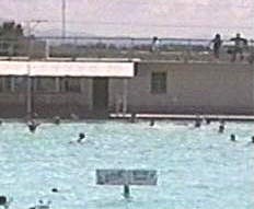
You will find hot springs pools throughout the San Luis Valley. Most of them are not very well advertized. Splashland geothermal outdoor public swimming pool is great for the family and is located one mile North of Alamosa on Colorado Highway 17. Valley View Hot Springs located in Penrose, Colorado has the unique combination of clothing-optional hot springs at the elevation of about 8,700 feet above sea level. It is open all year around. The facilities are charmingly rustic and primitive. Four natural ponds are located on the hillside for leisurely soaking. There is also lodging, RV space, campground, a small indoor pool and a woodburning sauna. From the junction of US 285 and CO 17 near Mineral Hot Springs, you would take the gravel road CR-GG due East seven miles. GPS Coordinates: 38°11'30.34"N 105°48'55.38"W |
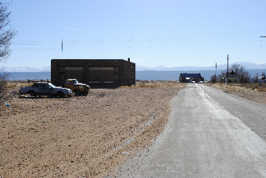 |
| There is an interesting place in Costilla County in the San Luis Valley called Mesita. It is along the "Ghost Railroad" the San Luis Southern Railroad. There are a number of very old (some boarded up) buildings constructed with black lava rock from a volcano that is just West of town. A little history on the ghostly Town of Mesita, based on research of how the area was originally developed can be found here. GPS Coordinates: 37° 5'54.06"N 105°36'7.62"W See More Photos & Video Here of Mesita, Colorado |
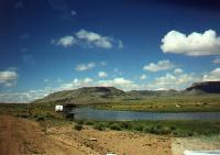 |
| Anyone who has heard the balled of Billy the Kid
has heard of the famous Rio
Grande River which runs through the San Luis Valley. There is still land available near and even along the bank of the
river for those who have the foresight to invest in the rare opportunities
that still exist in this part of the San Luis
Valley. GPS Coordinates: 37° 4'41.06"N 105°45'20.83"W |
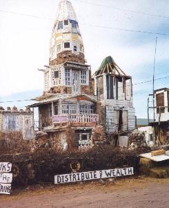 |
| Cano's Castle is a must see if you are in the area of Antonito, Colorado which
is located South of Alamosa along highway 285. It was built by Donald
"Cano" Espinoza, a Christian Vietnam Veteran as a castle of faith, after
his life was spared from the killing fields of the war. He has been
working on the castle according to published information since 1980. Cano
has also dedicated it to his mother, Margaret Trujillo Espinoza who passed
away in 1992 and his best friend, Gilbert "Pancho" Salazar who was killed
in Vietnam five days before his tour of duty was up. It is hard not to
gaze upon this structure without being deeply
moved. GPS Coordinates: 37° 4'51.86"N 106° 0'21.21"W |
![]()